Why Excavate at Tel Hadid?
History of Research
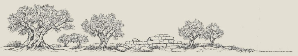
At first glance, Tel Ḥadid may appear as a quiet hill covered with olive trees. Yet beneath these orchards lies a site with a long and complex history—one that has only begun to be explored.
Modern research at Tel Ḥadid began almost by chance. In 1940, a mosaic floor dated to the Byzantine period (fourth–seventh centuries CE) was accidentally exposed by local residents, who alerted the British Mandate Department of Archaeology to salvage the remains. The mosaic, now displayed at the National Maritime Museum in Haifa, offered the first glimpse of the site’s archaeological potential. Despite this early discovery, Tel Ḥadid remained largely on the margins of scholarship for decades. It was noted in regional surveys and in studies of ancient road systems—particularly those tracing the routes connecting Jaffa with Jerusalem—but it did not become the focus of sustained investigation.

More extensive work took place in the 1990s, when large-scale salvage excavations were conducted in advance of the construction of a new highway. The original plan was to cut through the lower hill; however, the results of the excavations led to a change in plans, and tunnels were constructed in order to preserve the site. These excavations, directed by E. Brand, revealed a long sequence of human activity, extending back as early as the third millennium BCE. Particularly significant were finds from the late Iron Age (eighth–early sixth centuries BCE), including cuneiform tablets from the first half of the seventh century BCE that attest to the presence of a community of deportees settled here by the Assyrian Empire in place of the earlier population. These discoveries placed Tel Ḥadid within the broader context of imperial policies of forced migration and deportations in the ancient Near East. Subsequent salvage work added further evidence for activity during the Late Bronze Age (sixteenth–twelfth centuries BCE), Iron Age II (tenth–eighth centuries BCE), and the Byzantine period (fourth–seventh centuries CE), but much of the site remained only partially understood.
Since 2018, a new phase of research has been underway with the launch of the Tel Ḥadid Archaeological Project. Rather than focusing on specific periods or limited areas, the project approaches the site as a whole, seeking to reconstruct the longue durée of human activity from the earliest settlement to the remains of the village of al-Ḥaditha in the Ottoman and British Mandate periods. Our excavations have already brought to light significant insights into four key horizons: the Iron Age, the Hellenistic period, the Byzantine period, and the modern era. Yet much of the site remains unexplored, and each of these phases continues to raise new questions.
The Iron Age

Beneath the olive-covered slopes of Tel Ḥadid lie the remains of a community shaped by displacement and adaptation. During the late 8th and much of the 7th centuries BCE, the site formed part of the Assyrian provincial system, situated along the major north–south routes crossing the coastal plain and thus serving the needs of the empire. Its position at the junction of these corridors made it an ideal location for the resettlement of populations moved across the empire.
Previous excavations in Area A, including cuneiform tablets, point to the presence of deportees settled at the site by Assyrian authorities. Yet beyond this historical framework, much remains unknown about their everyday lives. How did these communities organize themselves in a new environment? How did they build their homes, produce their food, and interact with the surrounding landscape? And to what extent did they maintain, transform, or abandon earlier traditions?
Excavations at Tel Ḥadid aim to address these questions by focusing on the material traces of daily life in two excavation areas (AAU and BB). We study architecture, installations, small finds, and patterns of activity preserved beneath the olive orchards. The goal is not only to document an Assyrian-period settlement, but to understand how displaced communities adapted to a new setting and created a lived environment within an imperial framework.
The Hellenistic Period
In the Hellenistic period, Tel Ḥadid once again emerged as a site of strategic and symbolic importance, overlooking the routes that crossed the coastal plain and connected it with the highlands. Historical sources describe Ḥadid (Adida) as a fortified stronghold in the time of the Hasmoneans, but the archaeological remains suggest a more complex picture—one that is now beginning to come into focus through excavation.
At the center of this phase stands a monumental, fortified podium structure uncovered on the mound in two excavation areas (T1 and T2). Built with carefully laid stones and commanding the surrounding landscape, this installation forms a focal point for understanding the Hellenistic-period occupation of the site. Its scale and prominent placement indicate that Tel Ḥadid was more than a peripheral settlement—it was a site invested with meaning and authority.
Excavating the Hellenistic levels means working around and beneath this structure, tracing its construction, use, and eventual transformation. Set within a landscape now covered by the remains of the village, a lookout post, and olive groves, the podium anchors a phase of activity that reflects both regional conflict and local initiative. It offers a unique opportunity to explore how architecture, power, and landscape intersected at Tel Ḥadid during a period of profound political change.

The Byzantine Period

The Byzantine period at Tel Ḥadid is closely tied to agricultural production and the organization of the rural landscape. While the discovery of a mosaic floor in 1940 first drew attention to this phase, it is the extensive system of rock-cut wine presses that now provides the clearest insight into life at the site during late antiquity.
Carved directly into the bedrock across the slopes of the lower hill (such as in our Area CC), these installations point to large-scale wine production as a central economic activity. Their distribution suggests an integrated system of cultivation, processing, and possibly storage, embedded within the broader agricultural networks of the Byzantine province: “Palaestina Prima”. The slopes that are today covered with olive orchards likely formed part of a similarly intensively managed landscape, where vines, terraces, and installations structured both labor and production.
Through the excavations we seek to understand how this system functioned in practice. Were these presses operated by individual households or organized on a larger scale? How was production linked to regional markets? And how did the settlement itself relate to these agricultural installations? Working within the orchards that now cover the site, archaeologists can trace the continuity and transformation of land use, revealing how Tel Ḥadid participated in the economic and social fabric of the Byzantine countryside.
The Study of al-Ḥaditha
The remains of the village of al-Ḥaditha, still visible among the olive orchards that cover the tell, form an integral part of Tel Ḥadid’s long history. Rather than treating this phase as separate from the archaeological site, the project approaches al-Ḥaditha as a continuation of human activity on the hill, shaped by local traditions, regional dynamics, and modern transformations. Ongoing research combines archaeological remains, historical sources, and oral histories to reconstruct life in the village and its relationship to the surrounding landscape.
Learn more about al-Haditha…


Site Map
Explore the excavation areas with the interactive map.